Colombia · La Mojana · Putumayo

Process the flood in space.
Answer the questions on the ground.

Humanitarian flood response is information-bound, not resource-bound. The knowledge to save lives already exists in hundreds of PDFs that nobody can read in an emergency.

humaid puts a small AI on a satellite to spot the flood, sends a tiny alert to ground, and unlocks a pre-synced, role-specific Q&A on a local device that works without internet.

Two live model systems on this page: ask the knowledge base (471 bilingual Q&A pairs · Nomic + DuckDB) or run flood detection on a before/after Sentinel-2 pair (fine-tuned LFM2-VL-450M).

  • 471bilingual Q&A pairs
  • 17source PDFs indexed
  • ~200 Balert payload size
  • 0internet required, post-sync

The problem

Five disconnects between the knowledge and the people who need it

The information exists. The technology exists. People still drown, lose their homes, and re-learn the same lessons every cycle. The gap isn't knowledge — it's delivery.

  1. 01

    Risk maps speak a language no one in the wetland reads

    UNGRD, IDEAM, the World Bank and Copernicus produce hazard atlases in GIS, SAR and hydraulic-modelling jargon. A campesino in Caimito or a JAC president in Sincelejito can't use them.

  2. 02

    Responders can't search 314-page PDFs in a crisis

    The lessons of Mocoa 2017 and La Mojana 2021 are written down — in hundreds of pages of reports. So WASH gaps get re-discovered, triage protocols get improvised, the same lesson is re-learned every cycle.

  3. 03

    Cloud-based satellite imagery arrives days late

    La Mojana is >50% cloud-cover during the wet season. The bandwidth from satellite to data centre to response team is the bottleneck. By the time the imagery is processed centrally, the actionable window is gone.

  4. 04

    Numerical alerts don't translate to human actions

    "Río Putumayo nivel crítico 11.5 m" tells the IDEAM duty officer something. It tells the family in the zona ribereña nothing — about whether to leave, with what, where the albergue is, who to call.

  5. 05

    The network goes down with the power

    Cell towers fail, internet drops, roads cut — exactly when the most actionable decisions are being made. Cloud dashboards and web portals are unreachable in the first 6–72 hours.

The solution

Three components that close the loop — and keep working when the network goes down

                             SPACE
              ┌─────────────────────────────┐
              │  small VLM on satellite     │
              │  (LFM2.5-VL-450M, ~450 MB)  │
              │  Sentinel-2 / Sentinel-1    │
              │  image  →  ~200 B JSON      │
              └──────────────┬──────────────┘
                             │
                             ▼
   ┌─────────────────────── EARTH ─────────────────────────┐
   │  ┌─────────────┐         ┌──────────────────────┐     │
   │  │ Community   │ offline │ Local app            │     │
   │  │ station     │  LAN    │ - role-personalised  │     │
   │  │ (sync hub)  │ ◄────►  │ - phase-aware        │     │
   │  │             │         │ - region-specific    │     │
   │  └─────────────┘         │ - works offline      │     │
   │                          └──────────────────────┘     │
   └───────────────────────────────────────────────────────┘

01

Onboard satellite inference

A 450 MB vision-language model fine-tuned on Colombian flood events runs on the satellite itself. It ingests Sentinel-1 SAR + Sentinel-2 imagery onboard and emits a ~200-byte JSON alert instead of downlinking the raw tile.

  • No central data centre in the loop — alert reaches ground next overpass
  • SAR sees through cloud cover that defeats optical imagery
  • No per-tile cloud bill; runs on compute already in orbit

02

Community station — offline-first sync

A solar-tolerant Raspberry-class node at a school, clinic, JAC or alcaldía. Receives JSON alerts via radio, satellite link or SMS gateway; serves the synced knowledge base over local Wi-Fi.

  • Pre-synced before the crisis with the content that's hard to reach mid-event
  • Past incident reports for this exact location
  • Evacuation routes, albergue assignments, cluster contacts

03

Local app — role × phase × region

Phone, tablet, or laptop client. Works without any network once pre-synced. The same JSON alert routes to a different first screen based on who you are and where you live.

  • A community leader sees triage, shelter, AHE registration
  • A municipal official sees Ley 1523 triggers, EDAN forms
  • A Cruz Roja responder sees swift-water gates, manejo de cadáveres
  • Every answer cites the source PDF — accountability stays intact

Both systems are running on this page.

The knowledge base side uses Ollama + Nomic embeddings + DuckDB cosine search — the same stack that runs on a Raspberry Pi at a community station.

The flood-detection side runs the fine-tuned LFM2-VL-450M directly via llama.cpp — the same compact build we want to run on a CubeSat.

Open the demos →

The Zenú already solved this — once

500,000 hectares. 2,000 years. Then it was forgotten.

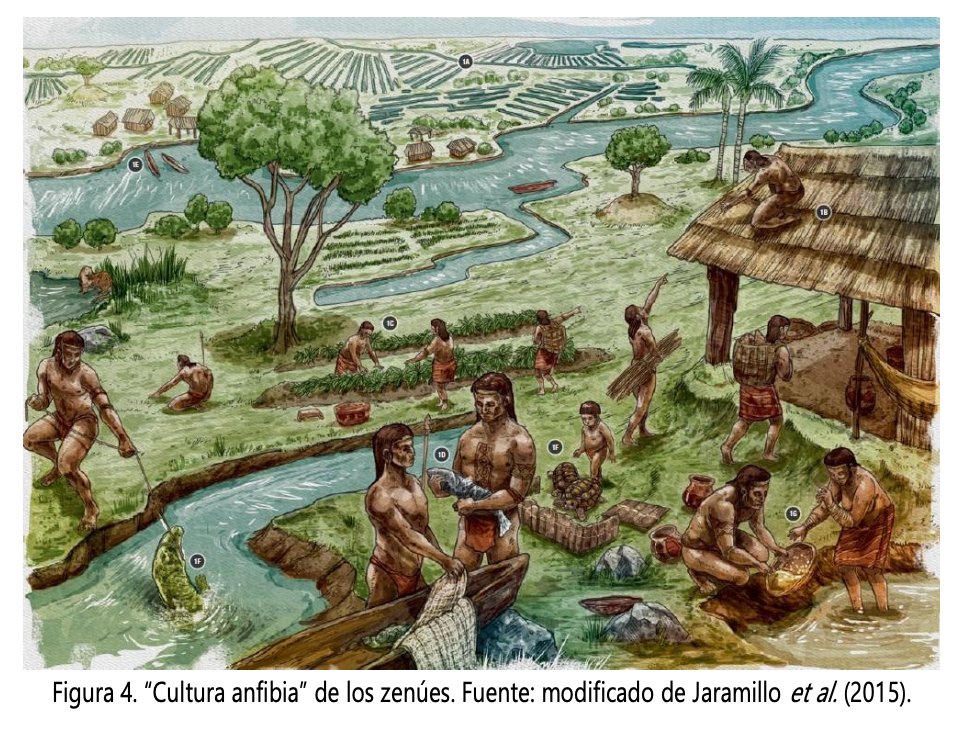
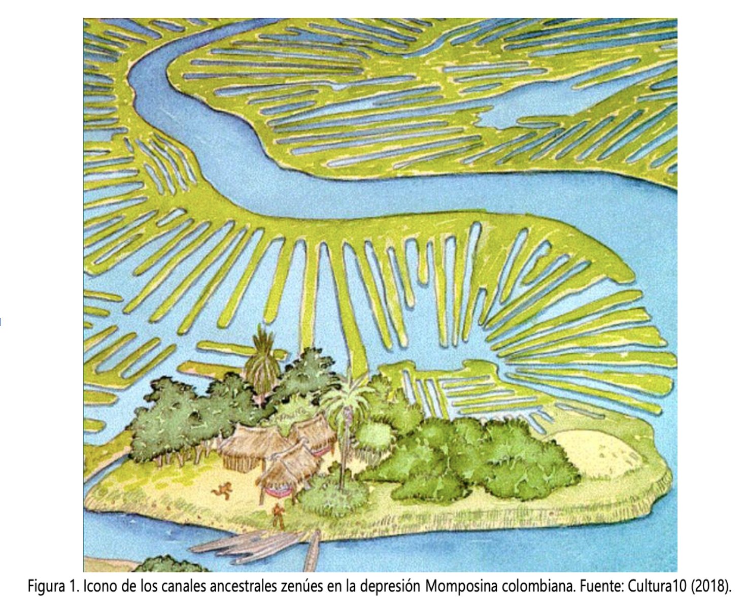
La Mojana is a 500,000-hectare wetland in northern Colombia where the Cauca, San Jorge and Magdalena rivers meet. For roughly two millennia before the Spanish arrived, it was home to the Zenú— pre-Columbian hydraulic engineers whose canal-and-camellón system embraced the seasonal floods rather than fighting them.

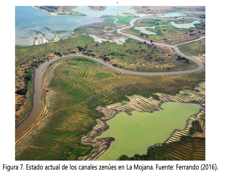
The faint herringbone patterns still visible from satellites today are theirs. So is the population estimated in the hundreds of thousands — denser than today.

Then European contact, depopulation and centuries of neglect collapsed the system. The drainage logic was forgotten. By the 20th century, the response had inverted: build dikes that try to keep water out instead of channels that move it through. The Cara de Gato dike has broken in 2021, 2024 and 2025.

The Zenú had landscape-literacy delivered by living in the landscape. We won't get that back. But we can build a system that delivers an analogous form of literacy — fast, verified, localised — through a pipeline that doesn't depend on the very infrastructure floods destroy.

Zenú canal remnants visible from above
Zenú canal remnants — visible from above, still etched into the landscape.
Reconstruction of the Zenú hydraulic system
The hydraulic system: canals + camellones across 500,000 ha.
Contemporary La Mojana under chronic flooding
Today: chronic flooding under a dike-failure regime. Cara de Gato has broken in 2021, 2024 and 2025.

Why now

Three curves crossed in 24 months. A fourth makes it urgent.

2023
2026
VLM size for visual reasoning
8B+ params, data-centre only
450M params, runs on a CubeSat
SAR coverage of La Mojana
Available but unprocessed
Operational EO services with UNGRD
Local retrieval cost
Cloud vector DB only
$100 device, no internet
Climate stressor
La Niña 2021-23 just started
Cumulative damage; El Niño 2026 incoming
Policy attention
Limited
Procuraduría intervention; Tribunal order

Traction

This is not a slide deck. It's a working set of components.

Ready

Research corpus

17 PDFs · ~60 MB

OCHA, UNGRD, ACAPS, CERF, FAO, IASC, UNICEF, IOM, IISD, SIDA, UNAL — all mirrored as searchable markdown. Plus ~80 curated external sources by theme.

Ready

Knowledge base

471 Q&A pairs

Bilingual EN/ES, role × phase × region tagged, source-cited. Built by 6 parallel agents in ~16 minutes wall time. Local sub-second retrieval via Nomic + DuckDB.

Pipeline built

Satellite fine-tune

LFM2.5-VL-450M

Full Modal H100 fine-tuning pipeline in Deno/TypeScript. Anthropic auto-labeller. 14 anchor locations, 9 events, ~115 paired samples. Sentinel-1 SAR re-attempt is a 2-week swap.

Demo

Events showcase

55-row geo-database

Static Mapbox viewer joining locations × events for La Mojana and Putumayo. JSON / CSV / GeoJSON export.

The ask

USD 250–350K · Year 1 · 14 anchor municipalities

Funding, partnerships, and first-pilot access to take humaid from working prototype to deployed system before the next ENSO cycle.

If any of this resonates — start with a 30-minute working call. We'll show the components live and walk through the architecture.

hello@humaid.app